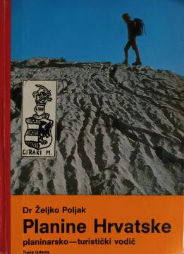
Planine Hrvatske

Planine Hrvatske

Željko Poljak

The author of the book is dr. Željko Poljak, doctor, university professor, author of works on mountaineering, the man who first raised the Croatian flag on the Himalayas.

This guide is intended for the reader with a wider cultural horizon, for whom it is not only important where a path leads. Therefore, it is not written according to established models, but is a reflection of the writer's personal understanding and experience. The basic guiding thought is that every mountain is different and it is important to point out the properties that make it different from the others. In this respect, mountainous Croatia offers an unusual wealth of diversity, not only with the contrast of the Pannonian and Dinaric mountain areas, but also with the contrast of individual and even neighboring mountains.

Editor
Željko Polak
Illustrations
Petar Lučić-Roki, Milan Đekić
Graphics design
Zlatko Smerke
Dimensions
17.5 x 13 cm
Pages
544
Publisher
Planinarski savez Hrvatske, Zagreb, 1986.
 
Distribution: 5,000 copies
 
Latin alphabet. Hardcover.
Language: Croatian.

Two copies are available

Copy number 1

Condition:Used, very good condition
Damages or inconvenience notice:
  • Slight damage to the cover

Copy number 2

Condition:Used, excellent condition
 

Are you interested in another book? You can search the offer using our search engine or browse books by category.

You may also be interested in these titles

Hrvatski planinarski atlas

Hrvatski planinarski atlas

Željko Poljak
Golden marketing.
Croatian. Latin alphabet. Paperback.
9.997.99
Osnove zemljopisa za I. razred srednjih i sličnih škola

Osnove zemljopisa za I. razred srednjih i sličnih škola

Ivo Juras

A general geography textbook intended for the first grade of secondary schools in the Independent State of Croatia. Contains the basics of physical and general geography, maps and illustrations. The work of the prominent Croatian geographer and pedagogue

Hrvatska državna tiskara, 1943.
Croatian. Latin alphabet. Paperback.
7.34
Atlas für Bürgerschulen und mehrklassige Volksschulen

Atlas für Bürgerschulen und mehrklassige Volksschulen

Anton E. Seibert

School atlas by Anton Emanuel Seibert for civic and multi-grade elementary schools, published in Vienna around 1901. Contains 19 main and 12 auxiliary maps of Europe and the world, as well as depictions of Austria-Hungary.

Eduard Hölzel Verlag, 1901.
Croatian. Latin alphabet. Hardcover.
54.36
Geografija - s ilustrovanom geografskom čitankom, za treći razred građanskih škola

Geografija - s ilustrovanom geografskom čitankom, za treći razred građanskih škola

A rare interwar edition of a geography textbook (Belgrade, 1934) with 11 color atlas maps and 150 illustrations. Valuable as an antiquarian and cultural-historical document of education and cartography in the Kingdom of Yugoslavia.

IP Narodna prosveta, 1934.
Serbian. Cyrillic alphabet. Hardcover.
18.36
Riznica znanja za mlade: Vasiona, Zemlja i vreme

Riznica znanja za mlade: Vasiona, Zemlja i vreme

The book "Vasiona, Zemlja i Mjesen" (1981) is a popular scientific work that explains the basic concepts of astronomy and earth science in an accessible way.

Jugoslavija, 1981.
Serbian. Latin alphabet. Hardcover.
6.00
Zemljopisni pregled Azije, Afrike, Amerike i Australije za niže razrede srednjih škola

Zemljopisni pregled Azije, Afrike, Amerike i Australije za niže razrede srednjih škola

Ivo Juras

A geography textbook for all continents (except Europe) intended for lower grades of secondary schools in the Independent State of Croatia. The work of the prominent Croatian geographer and pedagogue Ivo Juras, illustrated with interesting black-and-white

Hrvatska državna tiskara, 1942.
Croatian. Latin alphabet. Paperback.
6.74