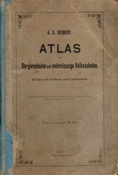
Atlas für Bürgerschulen und mehrklassige Volksschulen
Schulatlas von Anton Emanuel Seibert für städtische und jahrgangsübergreifende Grundschulen, erschienen um 1901 in Wien. Enthält 19 Haupt- und 12 Hilfskarten von Europa und der Welt sowie Darstellungen von Österreich-Ungarn.
Der Atlas für Bürgerschulen und mehrklassige Volksschulen ist ein geographischer Schulatlas des österreichischen Geographen und Pädagogen Anton Emanuel Seibert. Er war für den Geographieunterricht an Bürgerschulen und mehrklassigen Volksschulen der österreichisch-ungarischen Monarchie bestimmt. Der Atlas wurde Anfang des 20. Jahrhunderts in Wien vom renommierten Eduard Hölzel Verlag herausgegeben, einem der führenden europäischen Verlage für Schulatlanten und geographische Karten.
Der Atlas enthält 19 Hauptkarten und 12 Hilfskarten. Seine Verwendung wurde am 29. August 1901 vom Kaiserlichen und Königlichen Ministerium für Kultus und Bildung genehmigt. Der Preis für ein gebundenes Exemplar betrug 2,50 Kronen.
Der Atlas war als umfassender Überblick über die Welt und die damalige österreichisch-ungarische Monarchie konzipiert. Die ersten Karten zeigen die Hemisphären der Erde, die physische Geographie Europas und die politische Karte Europas. Ein besonderer Schwerpunkt liegt auf Österreich-Ungarn, dem sieben Karten gewidmet sind. Diese zeigen Relief, Flusssysteme, politische Gliederungen und einzelne Provinzen. Die österreichischen Alpenregionen, Wien und Umgebung, das Sudetenland, Krain, das Küstenland, Dalmatien, Bosnien und Kroatien-Slawonien sind dargestellt. Zu den ergänzenden Karten gehört eine Sprachkarte Österreich-Ungarns, die die ethnische und sprachliche Vielfalt der Monarchie historisch wertvoll dokumentiert.
Weitere Karten zeigen das Deutsche Reich, Skandinavien, Russland, die Länder West- und Südeuropas, Asien, Afrika, Australien und Ozeanien sowie beide Amerikas. Ergänzende Karten decken wichtige Regionen wie Palästina, das Nildelta, Südafrika, die östlichen Bundesstaaten der USA und Südost-Australien ab.
Der Atlas ist ein wertvolles Beispiel für Schulkartografie vom Beginn des 20. Jahrhunderts und eine bedeutende historische Quelle für das Studium der Geographie, politischer Grenzen und Weltanschauungen während der Zeit der österreichisch-ungarischen Monarchie. Da der Atlas auch das heutige Gebiet von Kroatien, Bosnien und Herzegowina sowie anderer mitteleuropäischer Länder umfasst, besitzt er auch einen besonderen regionalen kulturellen und historischen Wert.
Angeboten wird ein Exemplar
- Beschädigte Abdeckungen
- Abgenutzte Bezüge