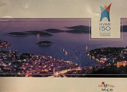
Hvar - 150 godina organiziranog turizma

Hvar - 150 godina organiziranog turizma

Turistička Zajednica Grada Hvara

Hvar is an island in Croatia, off the eastern coast of the Adriatic Sea. It belongs to the group of Central Dalmatian islands. Due to the large number of sunny days, it is often called Sunny Hvar.

Hvar belongs to the group of central Dalmatian islands. It is located in the Split-Dalmatia County, in the middle of a group of islands that are part of this county. Looking at the immediate neighborhood, to the north of it is the island of Brač, and to the south of it are Šćedro (from which it is separated by the Šćedor Channel), Vis (more towards the southwest), the Paklin Islands, Korčula and the Pelješac peninsula.

It is 72 km long and 10.5 km wide at its widest part. The total length of its coastline is 254.2 km. Its surface area is 299.7 km2, which makes it the fourth Croatian island by area. The highest peak is St. Nikola, on which there is a chapel, 628 m high.

The road connecting the town of Hvar on the west side and Sućuraj on the east side of the island is 84 km long. The island of Hvar is mostly covered with pine forest, which makes for an extremely pleasant climate and vineyards that produce up to 50,000 hectoliters of wine per year.

Dimensions
21 x 29.5 cm
Publisher
Turistička zajednica grada Hvara, Hvar
 
Latin alphabet. Paperback.
Language: Croatian.

No copies available

The last copy was sold recently.
 

Are you interested in another book? You can search the offer using our search engine or browse books by category.

You may also be interested in these titles

Rome and Vatican

Rome and Vatican

Loretta Santini

A practical and artistic city guide with a large map.

Plurigraf, 1974.
English. Latin alphabet. Paperback.
5.82
All Barcelona

All Barcelona

Escudo de Oro

Through 159 color photos you can see the illustrated history of Barcelona.

Editorial Escudo De Oro, 1984.
Croatian. Latin alphabet. Paperback.
6.42
All Montserrat

All Montserrat

Escudo de Oro

Through 132 color photos you can see the illustrated history of Montserrat.

Editorial Escudo De Oro, 1984.
English. Latin alphabet. Paperback.
6.48
Tradicionalna kuharica 2: Namirnice

Tradicionalna kuharica 2: Namirnice

You will find all the information about Italian foods that you wanted while cooking according to the recipes from the Traditional Cookbook in the Traditional Cookbook 2.

Leo Commerce, 1998.
Croatian. Latin alphabet. Hardcover.
16.32
Her Majesty's Tower of London

Her Majesty's Tower of London

The Tower of London is a medieval fortress that forms one of the central points of the city and is located on the eastern edge of the historic center of London along the very north bank of the River Thames.

Lofthouse international, 1976.
English. Latin alphabet. Paperback.
4.68
Tutta Verona

Tutta Verona

Giovanna Magi

Through 123 color photos you can see the illustrated history of Verona, with the addition of a map with a city plan.

Bonechi publishers, 1989.
Italian. Latin alphabet. Paperback.
6.22