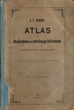
Atlas für Bürgerschulen und mehrklassige Volksschulen
School atlas by Anton Emanuel Seibert for civic and multi-grade elementary schools, published in Vienna around 1901. Contains 19 main and 12 auxiliary maps of Europe and the world, as well as depictions of Austria-Hungary.
Atlas für Bürgerschulen und mehrklassige Volksschulen is a school geographical atlas of the Austrian geographer and pedagogue Anton Emanuel Seibert, intended for teaching geography in civil and multi-grade public schools of the Austro-Hungarian Monarchy. The atlas was published in Vienna at the beginning of the 20th century by the reputable publishing house Eduard Hölzel Verlag, one of the leading European publishers of school atlases and geographical maps.
The atlas contains 19 main maps and 12 auxiliary maps, and its use was approved by the Imperial and Royal Ministry of Worship and Instruction on August 29, 1901. The price of the bound copy was 2.50 crowns.
The atlas was conceived as a complete overview of the world and the Austro-Hungarian Monarchy at that time. The first maps show the Earth's hemispheres, the physical geography of Europe and the political map of Europe. Special emphasis is placed on Austria-Hungary, to which seven maps are dedicated with reliefs, river systems, political divisions and individual provinces. The Austrian Alpine regions, Vienna and its surroundings, the Sudetenland, Kranjska, Primorje, Dalmatia, Bosnia and Croatia-Slavonia are covered. Among the auxiliary maps is the Language Map of Austria-Hungary, a valuable historical representation of the Monarchy's ethnic and linguistic diversity.
Further maps show the German Empire, Scandinavia, Russia, the countries of Western and Southern Europe, Asia, Africa, Australia and Oceania, and both Americas. The auxiliary maps cover certain important regions such as Palestine, the Nile Delta, South Africa, the eastern states of the USA, and southeastern Australia.
The atlas is a valuable example of school cartography from the beginning of the 20th century and a significant historical source for the study of geographic education, political borders and worldview during the period of the Austro-Hungarian Monarchy. Due to the content that includes today's territory of Croatia, Bosnia and Herzegovina and other Central European countries, the atlas also has a special regional cultural and historical value.
One copy is available
- Damaged covers
- Worn covers